Research Article - (2016) Volume 4, Issue 1
Keywords: Moisture flux; Divergence; African easterly jet; Tropical easterly jet; Heavy rainfall
One of the most crucial and dynamic phenomena of the West African climate system during the summer is the West Africa Monsoon (WAM) [1,2] a phenomenon caused by the seasonal reversal of winds due to differential heating between land and ocean [3,4] it plays a vital role in producing majority of the annual rainfall in the region [5-7]. In general, summer monsoon rainfall in Nigeria usually last between the first week of July until late September [8]. On 29th September, 2012, a heavy rainfall event occurred in major part of Nigeria. Historically, the rainfall recorded was of higher intensity. The Nigeria Meteorological Agency (NIMET) and National Emergency Management Agency (NEMA) reported that the event led to substantial damages (e.g. displacement of thousands of people, loss of crops, homes, farms, belongings, and livelihoods). The effects of the calamity enormously destabilized the economic situation of the Country. Presently, no studies examined the meteorological conditions which produced the September 29, 2012 heavy rainfall. However, such a heavy downpour leading to catastrophic flood disaster deserves a closer look at the atmospheric environment which led to the extreme phenomenon. Such incidences of heavy rainfall need to be monitored regularly in order to avoid the heavy damages that can be caused by subsequent flash flooding. Hence, this study aimed at diagnosing the atmospheric conditions that led to the heavy rainfall event of 29th September, 2012.
Nigeria which lies between 4° and 14°N latitude and longitude 4°to 14°E with elevation ranging from 6 to 1290 m above mean sea level, it is bounded on the North by the Republic of Niger, East by Cameroon and West by Benin Republic while the Southern boundary is Gulf of Guinea which is an arm of the Atlantic ocean. There are two main seasons which are wet (June-September) and dry (December-January). These periods vary from the Northern part to the Southern part of the country.
Daily rainfall data used for this study was obtained from the Tropical Rainfall Measurement Mission Multi-Platform Analysis (TMPA 3B43v7) [9,10] from September 27-30, 2012. Also daily zonal and meridional wind components and specific humidity were obtained from the European Centre for Medium-range Weather Forecast (ECMWF), Era- Interim reanalysis dataset for four pressure levels (1000, 850, 700, and 200 hpa) for the same time period. It is important to state that all the dataset used were at a spatial resolution of 0.25° by 0.25°.
Furthermore, the horizontal divergence of moisture flux (HFD) was computed for all the days under study over Nigeria using equation 1.
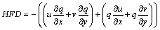 (1)
(1)
where q is the specific humidity (g/kg), u and v are respectively the zonal and meridional wind speed components (m/s). Negative HFD means convergence while positive means divergence.
Finally the vertical profile of the zonal wind was plotted to investigate the position and role of the Jet stream
Before diagnostically assessing the atmospheric condition that led to the heavy rainfall event. There is need to examine the spatial pattern of rainfall over Nigeria before, during and after the event. September 27 and 28 were used as the pre event days, September, 29 was the event day while September 30 was regarded as the post event day during the pre-event days there was little or no rainfall in the major part of the country (Figure 1). However, on the day of the event, it was observed that majority of the country experienced rainfall above the daily normal threshold. It is worth mentioning that South of latitude 9°N experience rainfall above 120 mm. The intensity of the rainfall had been reduced drastically on the post event day of September 30.
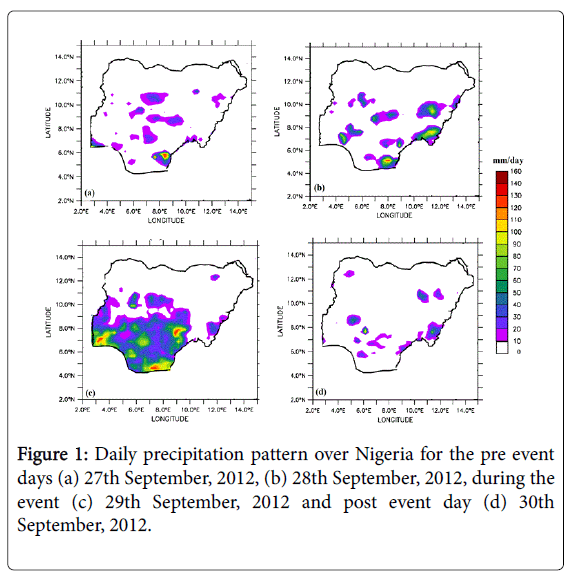
Figure 1: Daily precipitation pattern over Nigeria for the pre event days (a) 27th September, 2012, (b) 28th September, 2012, during the event (c) 29th September, 2012 and post event day (d) 30th September, 2012.
The characteristics of moisture flux at three different tropospheric layers are presented in Figures 2-4.
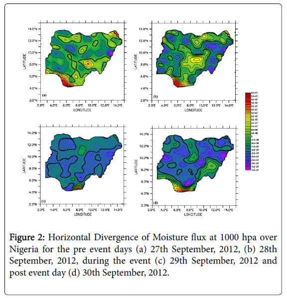
Figure 2: Horizontal Divergence of Moisture flux at 1000 hpa over Nigeria for the pre event days (a) 27th September, 2012, (b) 28th September, 2012, during the event (c) 29th September, 2012 and post event day (d) 30th September, 2012.
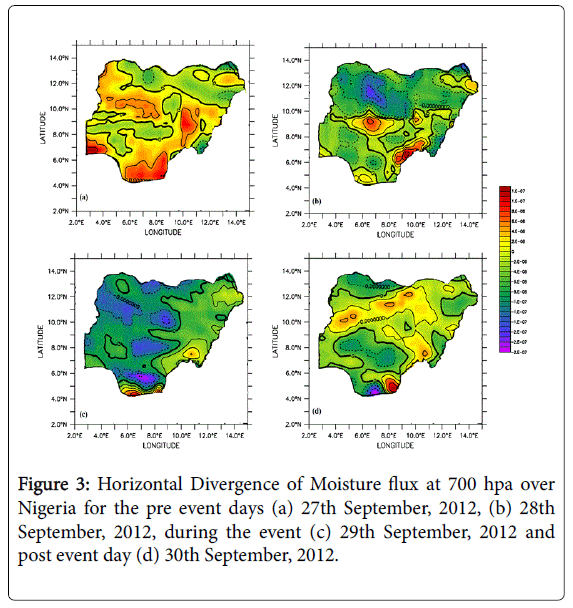
Figure 3: Horizontal Divergence of Moisture flux at 700 hpa over Nigeria for the pre event days (a) 27th September, 2012, (b) 28th September, 2012, during the event (c) 29th September, 2012 and post event day (d) 30th September, 2012.
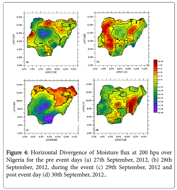
Figure 4: Horizontal Divergence of Moisture flux at 200 hpa over Nigeria for the pre event days (a) 27th September, 2012, (b) 28th September, 2012, during the event (c) 29th September, 2012 and post event day (d) 30th September, 2012.
Here the practical usage of equation 1 to diagnose the heavy rainfall event that led to flooding had been displayed. At the surface (1000 hpa), strong moisture convergence was observed on the pre and post event days while dominance of diverging wind was observed in major part of the country on the event day. However, in the middle troposphere (700 hpa), diverging wind with high humidity loadings dominated days 27, 28 and 29. The observed moisture convergence in the lower troposphere and divergence in the middle troposphere during pre-event days may imply strong upward motion of moist air; release latent heat due to condensation process (this available heat energy might be the source of low-level latent heat instability) and in turn intense rainfall delivery of September 29, 2012. Furthermore, at the upper troposphere, the HFD distribution depicts a wider spread of converging wind over the country in all the days considered. Thus high loading of upper-level moisture transport may have influenced the heavy rainfall South of 9°N. The results presented here are in mutual agreement with the assumption of Dine’s compensation which says “convergence at the surface will lead to divergence at upper level and vice versa”.
The dynamics of the atmosphere associated with rainfall over Nigeria is further assessed taking into consideration the zonal wind profile average for two latitudinal domains over Nigeria; South of 9°N, and North of 9°N as shown in Figure 5.
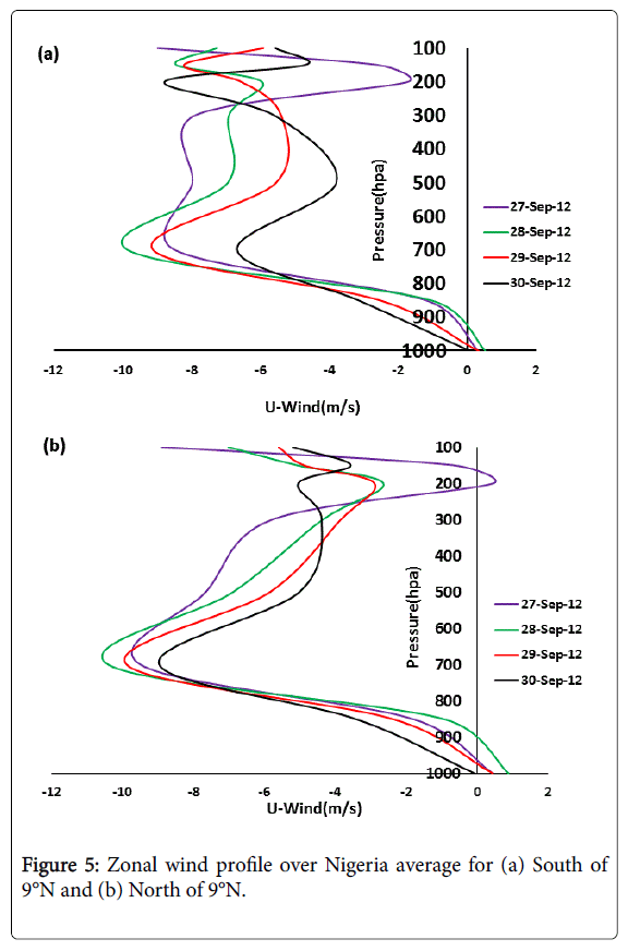
Figure 5: Zonal wind profile over Nigeria average for (a) South of 9°N and (b) North of 9°N.
The diagram illustrates the main dynamical large scale features associated with convective activity and rainfall delivery over Nigeria [11,12]. There was an appearance of the African Easterly Jet (AEJ) and Tropical Easterly Jet (TEJ) at 700 hpa and 200 hpa respectively in all five days considered South of 9°N. However, it is worthy to note that the intensity of the AEJ in the pre event days especially September 28, 2012 was stronger in magnitude (11 m/s), with observation of a reasonably distinct TEJ except for day 27. The zonal wind profile average at North of 9°N as shown in Figure 5b indicates a deeper moisture depth during the pre-event days with a considerable organised and high magnitude AEJ but with a disappearing TEJ. The disappearance of the Tropical Easterly Jet North of Latitude 9°N may be the reason for the little or no rainfall observed over the region. Hence it can be concluded that the combine appearance of a well distinct TEJ and AEJ South of 9°N may have impacted to a very large extent the development of deep moist convection that led to the heavy rainfall experienced over the region.
The atmospheric condition that led to the heavy rainfall event of September 29, 2012 over Nigeria has been diagnosed in this study. The spatial pattern of rainfall over Nigeria indicated that majority of the country experienced rainfall above the daily threshold especially South of 9°N. Furthermore, the analysis of the horizontal divergence of moisture flux revealed very important characteristics of the heavy rainfall over study region. The observed moisture convergence in the lower troposphere and divergence in the middle troposphere during pre-event days implies strong upward motion of moist air which may be responsible for producing the observed heavy rainfall. Similarly, the occurrence and dominance of the heavy rainfall event South of 9°N on 29th September, 2012 may be attributed to a very large extent the appearance of a well-organized and distinct AEJ and TEJ which impacted to the development of deep, moist convection.
